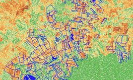
Radar Vegetation Index (RVI) and RVI for Sentinel-1 SAR data (RVI4S1)
Reading time
Content
Radar vegetation indices such as RVI and RVI4S1 represent a significant advance in remote sensing by using radar technology to monitor vegetation.
- RVI (Radar Vegetation Index):
- It is an index that is used to monitor crop growth.
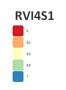
- RVI values range theoretically from 0 to 1.
- Values close to zero indicate bare soil or young plants.
- High values, close to 1, indicate fully developed plants.
- Calculation formula: RVI=8σHV/(σHH+σVV+2σHV), where: σHH and σVV are the polarized backscattering coefficients.
- RVI4S1 (RVI for Sentinel-1 SAR data):
- Is the derived radar vegetation index specific to Sentinel-1 satellite imagery.
- It is a more complex index that requires a more detailed procedure and often a software script for its calculation.