Normalized Difference Tillage Index (NDTI)
Reading time
Content

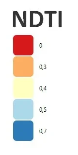
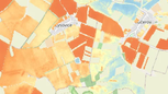
NDTI, which stands for Normalized Difference Tillage Index, is a specific index that allows to quantify the level of readiness of agricultural land. Its main purpose is to measure the differences between two bands of satellite imagery in the short-wave infrared spectrum, known as Short Wave Infra Red (SWIR).
The use of NDTI can provide farmers with valuable information about crop residues and tillage intensity on their land. While there are several different spectral indices for evaluating these factors, NDTI is often considered one of the most reliable for estimating crop residue coverage of the soil.
The main formula for the NDTI is: NDTI=(B11-B12)/(B11+B12), where B11 and B12 are the reflectances in the short-wave infrared band 11 and band 12 of the Sentinel-2 satellite images. Specifically, B11 is located at 1610 nm and B12 at 2190 nm.