Enhanced Vegetation Index (EVI)
Reading time
Content
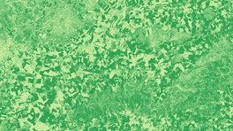
EVI, which stands for Enhanced Vegetation Index, is a modern and sophisticated vegetation index designed to offer greater sensitivity and accuracy compared to traditional vegetation indices such as NDVI. EVI takes into account effects such as cloud cover, smog, aerosols and cloud shadows that can affect vegetation measurements from satellite imagery.
EVI is designed with the intention of correcting for atmospheric noise and saturation that may be present when using other indices. Additionally, because it uses blue, red, and NIR (near-infrared) spectra, EVI offers a more comprehensive view of vegetation health in a particular area.
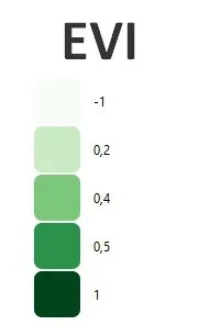
EVI values range from 0 to 1. A value near 1 indicates healthy vegetation, while a value near 0 indicates unhealthy vegetation. In practice, EVI has proven to be a very effective tool for monitoring changes in vegetation and inferring biophysical characteristics of vegetation.
The formula for calculating EVI is as follows: EVI=G×(NIR-R)/(NIR+C1×R-C2×B+L), where:
- G is the gain factor (usually set to 2.5),
- C1 and C2 are the atmospheric resistance coefficients,
- L is an adjustment to correct for non-linear transmission of NIR and red radiation through vegetation.