Normalized Difference Vegetation Index (NDVI)
Reading time
Content
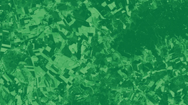
NDVI, which stands for Normalized Difference Vegetation Index, is one of the most popular vegetation indices in the field of geoinformatics and remote sensing. This index uses red (R) and near-infrared (NIR) spectra to assess the density and health of vegetation cover.
The main formula for the NDVI is: NDVI=(NIR-Red)/(NIR+Red)
Different satellites have different spectral bands and therefore NDVI can be specified as follows:
- For Sentinel 2: NDVI=(B8-B4)/(B8+B4)
- For Landsat 8: NDVI=(B5-B4)/(B5+B4)
- For Landsat 4-7: NDVI=(B4-B3)/(B4+B3)
Why is NDVI so important? It is strongly associated with the species and health of vegetation. However, keep in mind that it is sensitive to soil brightness and atmospheric conditions that can affect results.
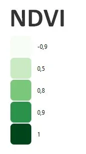
Theoretically, NDVI values range between -1 and +1. Negative values usually indicate surfaces other than plants, such as snow, water or clouds. Values close to zero may indicate bare soil. Positive NDVI values, especially between 0.1 and 0.7, indicate the presence of plant cover with higher values indicating denser vegetation.