| Karel Charvát
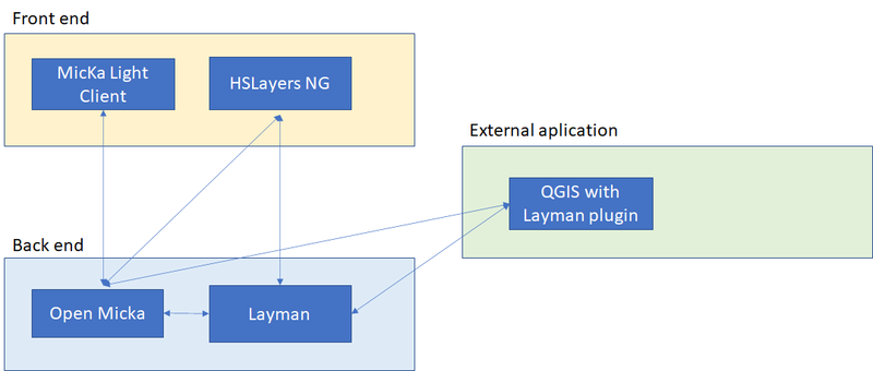
The management of spatial information in SmartAfriHub is composed of five basic components divided on:
- Back end
- Open Micka
- Layman
- Front end
- Micka Light Client
- Layman
- External Application
- QGIS with Layman plugin
Open Micka
Open Micka is a web application for management and discovery geospatial metadata. You can find more on http://micka.bnhelp.cz/ and you can see also cone on GitHub https://github.com/hsrs-cz/Micka
Layman
Layman is a web service for publishing geospatial data online through REST API. It accepts vector data in GeoJSON or ShapeFile format together with visual styling and makes it accessible through standardized OGC APIs: Web Map Service, Web Feature Service, and Catalogue Service. Even large data files can be easily published thanks to chunk upload and asynchronous processing. More info on GitHub https://github.com/jirik/layman
Micka Light Client
Micka Light Client will allow publishing easy metadata for Spatial Data It will be implemented in next days.
HSLayers NG
HSlayers NG is a web mapping library written in Javascript. It extends OpenLayers 6 functionality and incorporates basic ideas from the previous HSlayers library, but uses modern JS frameworks on the front end and provides better adaptability. That's why NG ("New Generation") is added to its name. It is still under development and serves as open source. HSLayers modules are designed in a modular way that allows the modules to be loosely attached and removed to meet all dependencies. Checking dependencies is done automatically. More info is here https://ng.hslayers.org/ and on GitHub https://github.com/hslayers/hslayers-ng
QGIS with Layman Plugin
QGIS is a Free and Open Source Geographic Information System https://qgis.org/en/.This plugin is an extension of the geographic information system QGIS. It is the client application usable like map layer provider for Layman server. The main idea is to create and edit layers and create map compositions structures on local stations, that is possible to upload to the server. It can also load map compositions/layers in the opposite direction as a client of WMS and WFS services. More info will come soon.